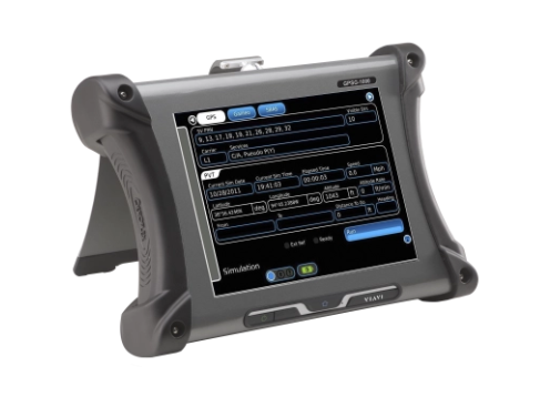


VIAVI - GPSG-1000 Portable Satellite Simulator
- • System - Simulated 3D position may be user entered in latitude/longitude/height format or 3D position may be dynamically simulated utilizing a multi-leg waypoint entry scheme. An unlimited number of navigation plans may be saved and recalled under a user assigned name. A built-in GPS receiver allows positional simulation in the form of a range, heading and altitude based on current test set position.
- • Satellite Vehicle (SV) Selection - All GPSG-1000 configurations allow GPS and Galileo satellites to be mixed. (The Galileo codes may be updated via a text file upload.)
- • Waypoints - Waypoint legs join up in 3D space, with either range rate or altitude-rate being auto calculated. Trajectory changes are calculated to simulate real world navigation, i.e. waypoint leg heading changes utilize realistic rates of turn; altitude changes utilize realistic rates of descent or climb. Way points may be entered in LAT/LONG form or automatically recalled from an airport or city database.
- • SBAS - SBAS satellites WAAS/EGNOS may be manually selected or automatically based on simulated position.
- • Setup - The setup page allows system, user and RF connection parameters to be set by the user.
The configurable GPSG-1000 is a truly portable, easy-to-use GPS and Galileo positional simulator. It fills a gap in the market by providing a low-cost 12 channel test set that creates three-dimensional simulations. This new simulator is also designed to be software upgradable. Versatile time-saving portable test set for GPS/GALILEO receivers including WAAS/EGNOS SBAS simulation
Available through your GSA Supplier
Versions, Options and Accessories
- • 87339 GPSG-1000 12 Satellite Simulator NSN: 6625-01-616-2712
- • 140607* GPSGOPT3 ADS-B Integrity Test Option * Includes cables and accessories
Standard Accessories
- • 88493 Transit case (qty 1)
- • 67374 Power supply
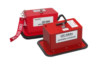
- • 87636 Antenna coupler
- • 90113 RX Antenna
- • 90114 Cable, coax 50 ft.
- • 62302 Power cord (U.S)
- • 64020 Power cord (European)
- • 88753 Coupler shot bag
- • 88037 Operation Manual (CD)
- • 88038 Getting Started Manual (paper)
Optional Accessories
- • 87040 External battery charger
- • 86196 Spare battery pack
- • 90106 Kit, Antenna coupler placement pole 8 ft.
- • 91136 Kit, CPLR Dual GPS Antenna System
- • 91137 Kit, CPLR Triple GPS Antenna System
- • 113108 Kit, GPS Receiver Termination, 190 Ohms
- • 89023 Maintenance Manual (CD)
More Product Information

- • DoD AIMS 03-1000A (Change Notes 1,2,3) Mark XIIA certified
- • Supports DoD AIMS 04-900A Option A - KIV-78 and Option B - KIV-77, & SIT-2010 crypto appliqués.
- • Transponder Test Modes 1,2,3/A, C, S (EHS/ELS), 4, Mode 5 (Level 1 and 2
- • Interrogator Test Modes 1, 2, 3/A, C, S, 4, Mode 5, TCAS, ETCAS (Level 1 and 2)
- • DO-260B compliant; ADS-B Out test capability
- • Reliable FAR Part 43 Appendix ‘F’ ERP and MTL testing in high multi-path environments
- • Provides >20 dB of antenna isolation for Mode S transponder altitude and diversity tests
- • Reduces interference with air traffic control and nearby aircraft
- • Rugged design for ramp use
- • Fits most ‘Shark Fin’ L-Band antennas
- • Quick action antenna grip/release action
- • Integrated touch screen with live fiber viewing
- • Auto-Center
- • Auto-Focus
- • Built-in fiber endface analysis
- • User-selectable acceptance profiles
- • Stores results on device or export
- • WiFi and USB connection capabilities
- • Solid-state circuits and LCD backlit display for low power consumption and high reliability
- • Battery-powered for complete portability and ease of maintenance
- • Lightweight aluminum case has hinged compartment in lid for test lead storage
- • Small size permits testing in restricted spaces
- • Push-button "extended range" switch permits readings up to 9,999 pf or 10,000 megohms - over-range indication on LCD
- • Tested and approved for use in any function with fuel in tanks; battery power eliminates need for voltage (safety) checks
- • Software-driven design allows for field updates for adding new features, capability or modifications due to industry changes
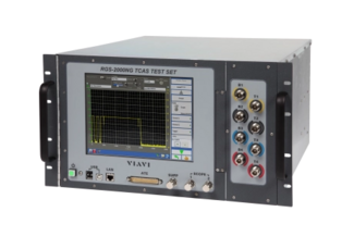
- • TCAS and ADS-B Target Generator
- • Simulates 32 dynamic and 568 static ADS-B/TCAS targets at 1090 MHz in scenario mode
- • Simulates 32 dynamic and 1,500 static UAT targets at 978 MHz as airborne or ground link messages 1
- • Simulates blocks of up to 1,000 messages for Ground Station and TCAS messages at 1030 MHz 2
- • ADS-B squitter encode/decode
- • More test capability than any tester in the market, all packed into one box
- • Pulse and frequency measurement Transponder test option for Modes A, C, S
- • Optional Command set emulation for SDX-2000, ATC-1400A and S-1403DL
- • 10.4 inch touch screen LCD display for operator control of all test set capabilities or can be remotely controlled via GPIB or Ethernet
- • Four port antenna simulation
- • Hybrid surveillance
- • Six independent transmitters and two receivers
- • Data parsing for analysis
1Requires RGSNGOPT10 Transponder, RGSNGOPT14 Multi-receiver, or RGSNGOPT13 UAT options
2Requires RGSNGOPT14 Multi-receiver
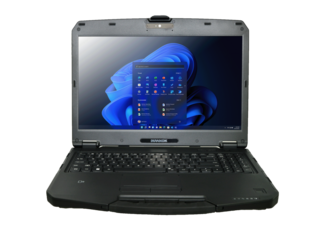
- • 15.6” FHD DynaVue® SR display with 1000 nits
- • 12th Generation Intel® Core™ Processor
- • Intel® Wi-Fi 6E AX211 & Bluetooth® V5.3
- • GPS and 5G/4G LTE WWAN
- • Optional built-in smart card reader
- • Support RAID 0 and RAID 1
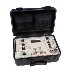
- • Easy to operate/calibrate
- • Annual calibration Lightweight / portable
- • Rechargeable battery or externally powered
- • Percent of battery capacity displayed
- • Self-test on power-up
- • Measures DC voltage Manual or Auto Ranging
- • 2 and 3 Wire Meggar
- • Compliant with Boeing Spec 10-61959 Rev H
- • MIL-STD-810 Method 511.4 certified
- • Traceable to NIST
- • Tests any AC or DC capacitive fuel, water, LOX/engine oil or other AC capacitive system*
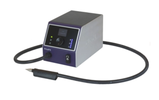
- • Uses a precise non-contact air-solvent-air sequence to blast and remove contamination particles
- • Comprehensive selection of precision cleaning tips for most fiber connector types
- • High performance air filter system
- • Hassle-free solvent management
- • Additional connections for foot activation pedal & backplane handset extension.

- • IFF Modes 1 & 2
- • TACAN/DME interrogator testing
- • Military E-TCAS
- • Transponder Auto Test (DO-181E)
- • Automated ADS-B AC 20-165B surface/air performance testing
- • ADS-B (Out) monitor and decode
- • ADS-B (In) target generation
- • UUT parametric tests
- • User programmable TCAS scenarios
- • Altitude encoder
- • Over-the-air, direct, or coupled testing
- • Battery operation for 6 hours plus

VIAVI
VIAVI is a leading worldwide provider of highly specialized test and measurement equipment and microelectronic solutions.
VIAVI Solutions is proud of our industry-leading network solutions for Telecommunications Service Providers, Equipment Manufacturers, Enterprises, and Entities in fields of Government and Avionics. VIAVI is consistently #1 or #2 in the markets we serve, including: Fiber, Cable, Access, Metro and Transport, RAN-to-Core, LandMobile and Military Radio and Nav/Comm and Transponder. We offer end-to-end network visibility and analytics that help build, test, certify, maintain, and optimize complex physical and virtual networks.
Our optical specialty products division is renown for expertise in anticounterfeiting pigment materials, 3D Sensing, and optical filters – holding #1 positions in those markets as well.
The pioneering spirit at VIAVI continues as we light the path to 5G with innovative test and measurement products, and lead the way with 3D sensing technology.
✈️ Avionics / Flightline
Download Line Card
Document
📡 Communications / RF
Download Line Card
Document